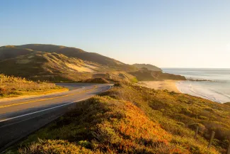
BIG SUR, California — Highway 1 closures turned travelers around Tuesday as Caltrans crews worked through the night clearing mud and rock debris from storm-damaged sections of the Big Sur coast, the latest disruption to one of the most iconic and geologically unstable stretches of highway in North America. The closure, triggered by rockslides from recent rainstorms, initially shut down a 45-mile segment from Ragged Point Inn in San Luis Obispo County to one mile south of Deetjen's Big Sur Inn in Monterey County on Monday, February 16, according to verified Caltrans reports. By Tuesday morning, crews had managed to partially reopen the highway, leaving a 6.8-mile segment closed from one mile south of Esalen Institute to two miles north of Lucia at Regent's Slide. That last detail matters. Regent's Slide just reopened in mid-January after a long-term closure during which construction crews completely rebuilt a section of the roadway. Now it's closed again, mud and debris blocking the same stretch that required total reconstruction just weeks ago. It's a sharp reminder of what maintaining infrastructure looks like in a coastal zone that routinely tries to reclaim the pavement.
Travelers Turn Around, Crews Keep Working
On Tuesday, drivers arriving at Highway 1 expecting to cruise the Pacific Coast Highway found barricades and detour signs instead. Many were tourists, drawn by the route's global reputation for dramatic cliffs, ocean views, and winding coastal access. The disappointment was palpable, but reactions remained measured. Travelers understood the reality: storms hit, rock moves, roads close. Caltrans has not provided an estimated reopening time. Crews continue clearing mud from the roadway at Regent's Slide, according to KSBY. The work is slow, precision-driven, and weather-dependent. Given the topography and the frequency of slides in this corridor, optimism about timelines is rarely warranted.
A Vulnerable Highway With a Long History of Disruption
This closure is not an anomaly. Highway 1 through Big Sur has been shuttered repeatedly over the years due to landslides, erosion, washouts, and storm damage. The roadway clings to cliffs above the Pacific, threading through geology that shifts with heavy rain, seismic activity, and seasonal erosion. Every major storm system tests the highway's viability. Some years, it loses. The recent rebuild at Regent's Slide represented a significant investment in stabilizing a notoriously unstable section. Crews didn't patch it; they rebuilt it. The fact that debris has already forced another closure underscores the scale of the challenge Caltrans faces. As National Today reported, "This closure of a major section of Highway 1 highlights the ongoing challenges California faces in maintaining its critical transportation infrastructure in the face of extreme weather events and natural disasters." That's not editorializing. It's accurate. Infrastructure resilience in environments like Big Sur is expensive, labor-intensive, and never permanent. You rebuild, the earth moves, you rebuild again.
What This Means for Travelers
If you're planning a trip along the Pacific Coast Highway, expect closures. Check Caltrans road conditions in real time before you go. The Big Sur stretch is gorgeous, but it's also fragile and prone to sudden, unannounced shutdowns. There's no workaround when a section closes; Highway 1 is the only coastal route through this area. Your alternative is Highway 101 farther inland, which skips the coast entirely. For travelers already en route when closures hit, the experience can be frustrating. You've booked lodging, planned photo stops, coordinated timing. A sudden 6.8-mile closure doesn't sound like much until you realize it cuts access to entire segments of the coast, forcing long detours or trip cancellations. Tourism businesses in Big Sur also take a hit. Every closure reduces visitor numbers, cuts revenue for inns, restaurants, and tour operators, and increases uncertainty for anyone trying to run a seasonal business in a region already challenged by wildfire risk, water availability, and high operating costs.
Practical Advice
If you're driving Highway 1 in the coming days or weeks, assume the road may be closed. Pack extra water, fuel, and snacks. Have offline maps. Monitor Caltrans updates and local news. Don't assume a reopening date holds; crews clear debris only to have more slides follow the next rain. If you encounter a closure, turn around. There's no shortcut, no bypass, no dirt road alternative. The highway either works or it doesn't. Photographers should plan flexible itineraries. If you're shooting Big Sur for a project or assignment, build in buffer days. Conditions change fast. Weather apps are useful, but they won't predict a rockslide.
The Reality of Coastal Infrastructure
California spends millions maintaining Highway 1. Engineers study slope stability, drainage systems, and erosion patterns. Construction crews work year-round to keep the road passable. And still, storms win. Rock falls. Mud flows. Roads close. This isn't a failure of planning or maintenance. It's geology. The coast is dynamic, unstable, and unforgiving. The highway exists because people want access to one of the most visually stunning coastlines on the planet. That access comes with risk, cost, and periodic closures. For now, Caltrans crews keep clearing debris. Travelers keep turning around. The highway will reopen when it's safe, and it will close again when the next storm rolls through. That's the bargain you make when you drive Highway 1 through Big Sur. It's worth it, but only if you understand the terms.
About the Author

Jeff Colhoun
Jeff Colhoun is an acclaimed travel writer, photographer, and filmmaker, whose work is respected both in the United States and internationally.